Файл:Arab population israel 2000 en.png

Матеріал з Вікіпедії — вільної енциклопедії.
Перейти до навігації Перейти до пошуку
Повна роздільність(692 × 1575 пікселів, розмір файлу: 182 КБ, MIME-тип: image/png)

Wikimedia Commons logo Відомості про цей файл містяться на Вікісховищі — централізованому сховищі вільних файлів мультимедіа для використання у проектах Фонду Вікімедіа.

Опис файлу

Опис
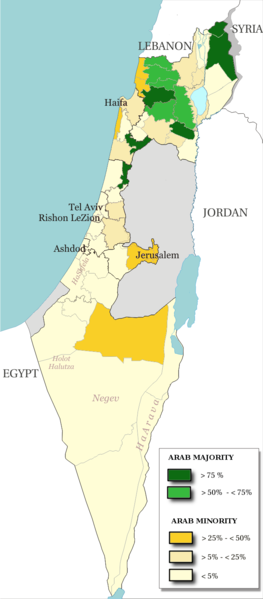
English: Map of the officials 50 "natural regions" of Israel, with their proportions of arab population. The map includ the Golan heights and east Jerusalem, two areas annexed by Israel, annexions not recognize by UNO. The map is based on the demographic situation 2000, and is based upon the arab population in Israel [PDF], a publication (Statistilite N°27) of the israeli Center Bureau of Statistics (CBS) diffused in november 2002.
Français : Carte des 50 "régions naturelles" officiellement reconnues par l'état, subdivision des 15 sous-districts, avec la proportion de population arabe. Cette carte inclue Jérusalem-Est et le plateau du Golan, tous deux annexés par Israël, mais dont l'annexion n'est pas reconnue par l'ONU. La carte est basée sur la situation de la population en l'an 2000, et est inspirée de the arab population in Israel [PDF], une publication (Statistilite N°27) du Center Bureau of Statistics israélien (CBS) diffusée en novembre 2002.
Час створення
Джерело Own work, derivative work of: File:Israel population density.png
Автор Christophe cagé
Інші версії File:Arabe population israel 2000 fr.png

Ліцензування

© Власник авторських прав на цей файл, Israel Central Bureau of Statistics, дозволяє використовувати файл для будь-яких цілей, при умові збереження інформації про власника авторських прав. Дозволяється розповсюдження цього файлу, створення похідних робіт, а також комерційне та будь-яке інше використання.
Зазначення авторства:
The Central Bureau of Statistics (CBS), {{{filename}}}, ({{{access-date}}}), [{{{link}}} available online] copied and distributed as is in accordance with the CBS license.

{{{template}}} According to the CBS license, you may not make the following use of the Information, whether by positive act or by omission:
  • present the Information in a misleading manner;
  • present the Information in a way that suggests that the Central Bureau of Statistics, or the State of Israel, supports or endorses you or your use of the Information;
  • make use of the Information in a manner that breaches any applicable law;
  • make use of the Information in a manner that infringes a person's privacy, including merging the Information with other sources of information with the intent of attempting to identify any individual person, business or organization;
  • present the Information in such a manner that gives the appearance that you may have received, or had access to, information held by the Office about any identifiable individual person, business or organization.
Я, власник авторських прав на цей твір, добровільно публікую його на умовах таких ліцензій:
GNU head Дозволяється копіювати, розповсюджувати та/або модифікувати цей документ на умовах ліцензії GNU FDL версії 1.2 або більш пізньої, виданої Фондом вільного програмного забезпечення, без незмінних розділів, без текстів, які розміщені на першій та останній обкладинці. Копія ліцензії знаходиться у розділі GNU Free Documentation License.
w:uk:Creative Commons
зазначення авторства поширення на тих же умовах
Цей файл доступний на умовах ліцензій Creative Commons Attribution-Share Alike 3.0 Unported, 2.5 Generic, 2.0 Generic та 1.0 Generic.
Ви можете вільно:
  • ділитися – копіювати, поширювати і передавати твір
  • модифікувати – переробляти твір
При дотриманні таких умов:
  • зазначення авторства – Ви повинні вказати авторство, надати посилання на ліцензію і вказати, чи якісь зміни було внесено до оригінального твору. Ви можете зробити це в будь-який розсудливий спосіб, але так, щоб він жодним чином не натякав на те, наче ліцензіар підтримує Вас чи Ваш спосіб використання твору.
  • поширення на тих же умовах – Якщо ви змінюєте, перетворюєте або створюєте іншу похідну роботу на основі цього твору, ви можете поширювати отриманий у результаті твір тільки на умовах такої ж або сумісної ліцензії.
Ви можете обрати ліцензію на ваш розсуд.

Підписи

Додайте однорядкове пояснення, що саме репрезентує цей файл

Об'єкти, показані на цьому файлі

зображує

186 138 байт

1575 піксель

692 піксель

Історія файлу

Клацніть на дату/час, щоб переглянути, як тоді виглядав файл.

Дата/часМініатюраРозмір об'єктаКористувачКоментар
поточний13:48, 15 липня 2014Мініатюра для версії від 13:48, 15 липня 2014692 × 1575 (182 КБ)Hruska~commonswikiReverted to version as of 08:23, 22 February 2009
13:47, 15 липня 2014Мініатюра для версії від 13:47, 15 липня 2014692 × 1575 (182 КБ)Hruska~commonswikiReverted to version as of 08:23, 22 February 2009 Revert Edit, The Golan and East Jerusalem de facto Israel, Syria giving Status qo
13:46, 15 липня 2014Мініатюра для версії від 13:46, 15 липня 2014692 × 1575 (182 КБ)Hruska~commonswikiReverted to version as of 08:23, 22 February 2009
15:38, 21 квітня 2009Мініатюра для версії від 15:38, 21 квітня 2009692 × 1575 (165 КБ)MeteorMaker~commonswiki{{Information |Description={{en|1=Map of the officials 50 "natural regions" of Israel, with their proportions of arab population. The map includ the Golan heights and east Jerusalem, two areas annexed by Israel, annexions not recognize by UNO. The map is
08:23, 22 лютого 2009Мініатюра для версії від 08:23, 22 лютого 2009692 × 1575 (182 КБ)Christophe cagé{{Information |Description={{en|1=x}} {{fr|1=x}} |Source=travail personnel (own work) |Author=Christophe cagé |Date=22 february 2009 |Permission=SEE LICENSE |other_versions= }} <!--{{ImageUpload|full}}-->

Така сторінка використовує цей файл:

Глобальне використання файлу

Цей файл використовують такі інші вікі:

Метадані