Файл:Generalgouvernement fur die besetzten polnischen gebiete.png
Перейти до навігації
Перейти до пошуку

Розмір при попередньому перегляді: 556 × 599 пікселів. Інші роздільності: 223 × 240 пікселів | 445 × 480 пікселів | 713 × 768 пікселів | 950 × 1024 пікселів | 1610 × 1735 пікселів.
Повна роздільність (1610 × 1735 пікселів, розмір файлу: 523 КБ, MIME-тип: image/png)
| Відомості про цей файл містяться на Вікісховищі — централізованому сховищі вільних файлів мультимедіа для використання у проектах Фонду Вікімедіа. |
Опис файлу
| Опис |
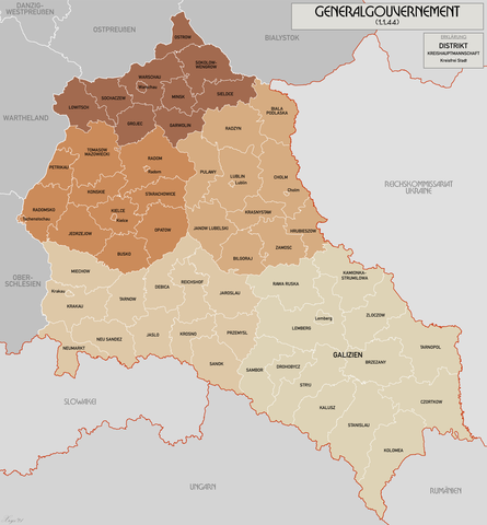
English: Administrative map of the Generalgouvernement für die besetzten polnischen Gebiete. |
| Час створення | |
| Джерело | Власна робота |
| Автор | XrysD |
| Інші версії | File:General Government for the occupied Polish territories.png |
Ліцензування
Я, власник авторських прав на цей твір, добровільно публікую його на умовах таких ліцензій:
Цей файл ліцензований на умовах ліцензії Creative Commons Attribution-Share Alike 3.0 Unported
- Ви можете вільно:
- ділитися – копіювати, поширювати і передавати твір
- модифікувати – переробляти твір
- При дотриманні таких умов:
- зазначення авторства – Ви повинні вказати авторство, надати посилання на ліцензію і вказати, чи якісь зміни було внесено до оригінального твору. Ви можете зробити це в будь-який розсудливий спосіб, але так, щоб він жодним чином не натякав на те, наче ліцензіар підтримує Вас чи Ваш спосіб використання твору.
- поширення на тих же умовах – Якщо ви змінюєте, перетворюєте або створюєте іншу похідну роботу на основі цього твору, ви можете поширювати отриманий у результаті твір тільки на умовах такої ж або сумісної ліцензії.

|
Дозволяється копіювати, розповсюджувати та/або модифікувати цей документ на умовах ліцензії GNU FDL версії 1.2 або більш пізньої, виданої Фондом вільного програмного забезпечення, без незмінних розділів, без текстів, які розміщені на першій та останній обкладинці. Копія ліцензії знаходиться у розділі GNU Free Documentation License. |
Ви можете обрати ліцензію на ваш розсуд.
Історія файлу
Клацніть на дату/час, щоб переглянути, як тоді виглядав файл.
| Дата/час | Мініатюра | Розмір об'єкта | Користувач | Коментар | |
|---|---|---|---|---|---|
| поточний | 10:11, 17 жовтня 2021 | | 1610 × 1735 (523 КБ) | XrysD | Incorporated typos KRUBIESZOW->HRUBIESZOW and CZORTZOW->CZORTKOW |
| 18:12, 11 жовтня 2021 |  | 1610 × 1735 (575 КБ) | Kamilhrub | Czortzow → Czortkow | |
| 10:30, 6 жовтня 2021 |  | 1610 × 1735 (575 КБ) | Kamilhrub | Corrected name Hrubieszow and southern borders of Bilgoraj, Hrubieszow and Zamosc districts, which didn't change after 1941 (source: Amtliches Gemeinde- und Dorfverzeichnis für das Generalgouvernement auf Grund der Summarischen Bevölkerungsbestandsaufnahme am 1. März 1943) | |
| 09:41, 8 травня 2015 |  | 1610 × 1735 (438 КБ) | RokerHRO | optipng -o7 -i0 → 21.79% decrease | |
| 10:36, 19 квітня 2015 |  | 1610 × 1735 (560 КБ) | XrysD | Komplett neue Karte. Grundkarte: Karte des Deutschen Reiches 1:100k, Karte von Mitteleuropa 1:300k, Mapa Administracyjna Rzeczypospolitej Polska 1:300k (Quelle mapyWIG). | |
| 16:18, 27 травня 2012 |  | 2299 × 2280 (398 КБ) | XrysD | Fixed typos | |
| 19:51, 26 травня 2012 |  | 2299 × 2280 (396 КБ) | XrysD | Changed version to all German Language. Changed all colours to use Bartholomew set. English language version can now be found under File:General Government for the occupied Polish territories.png | |
| 19:45, 26 травня 2012 |  | 2299 × 2280 (396 КБ) | XrysD | Changed version to all German Language. Changed all colours to use Bartholomew set. English language version can now be found under File:General Government for the occupied Polish territories.png | |
| 20:38, 23 січня 2009 |  | 2299 × 2280 (391 КБ) | XrysD | {{Information |Description= |Source= |Date= |Author= |Permission= |other_versions= }} | |
| 19:36, 29 листопада 2008 |  | 2299 × 2279 (367 КБ) | XrysD | {{Information |Description={{en|1=Administrative map of the Generalgouvernement für die besetzten polnischen Gebiete.}} |Source=Own work by uploader |Author=XrysD |Date=29/11/2008 |Permission= |other_versions= }} <!--{{ImageUpload|full}}- |
Використання файлу
Такі сторінки використовують цей файл:
Глобальне використання файлу
Цей файл використовують такі інші вікі:
- Використання в ar.wikipedia.org
- Використання в ast.wikipedia.org
- Використання в ba.wikipedia.org
- Використання в be-tarask.wikipedia.org
- Використання в ca.wikipedia.org
- Використання в cs.wikipedia.org
- Використання в de.wikipedia.org
- Використання в el.wikipedia.org
- Використання в es.wikipedia.org
- Використання в fi.wikipedia.org
- Використання в fr.wikipedia.org
- Використання в fr.wiktionary.org
- Використання в gl.wikipedia.org
- Використання в hu.wikipedia.org
- Використання в it.wikipedia.org
- Використання в sh.wikipedia.org
- Використання в simple.wikipedia.org
- Використання в sr.wikipedia.org
- Використання в sv.wikipedia.org
- Використання в www.wikidata.org
- Використання в zh.wikipedia.org