Файл:Bang Kachao Landsat.jpg
Bang_Kachao_Landsat.jpg (720 × 480 пікселів, розмір файлу: 246 КБ, MIME-тип: image/jpeg)
| Відомості про цей файл містяться на Вікісховищі — централізованому сховищі вільних файлів мультимедіа для використання у проектах Фонду Вікімедіа. |
Опис файлу
| Опис |
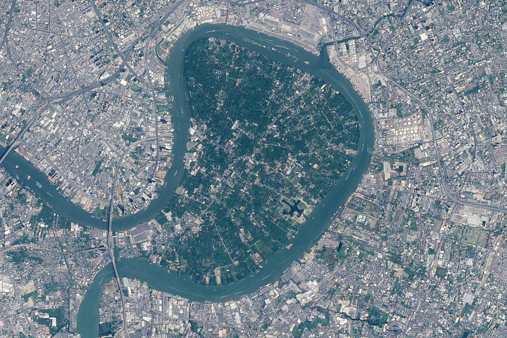
English: In the heart of Thailand’s most populous city, an oasis stands out from the urban landscape like a great “green lung.” That’s the nickname given to Bang Kachao—a lush protected area that has escaped the dense development seen elsewhere in Bangkok.
The city is built on the alluvial plain of the Chao Phraya River. Toward the southern end, near the Gulf of Thailand, is an old meander that never quite formed an oxbow lake. That meander traces the boundary of Bang Kachao, which TIME magazine once called the “best urban oasis” in Asia. On February 2, 2014, the Operational Land Imager (OLI) on Landsat 8 captured this natural-color view of Bang Kachao (also called Bang Krachao or Bang Kra Jao). The top image is a close up view of the region outlined with a rectangle in the bottom image. Bang Kachao is actually an island—albeit an artificial one. The Klong Lad Pho canal, built at the neck of the oxbow, allows water from the Chao Phraya to more quickly reach the sea. The canal contains floodgates that control water levels to prevent flooding. Immediately west of the canal is the Bhumibol Bridge, which twice crosses the Chao Phraya River. Look east of the mid-bridge interchange, however, and a stark transition occurs, as the urban jungle gives way to about 2,000 hectares of rural jungle, villages, and farmland. According to a travel story in The New York Times, Bang Kachao is gaining popularity among tourists lured by bike tours, a floating farmers’ market, and the relaxed atmosphere.[1] |
| Час створення | |
| Джерело | http://earthobservatory.nasa.gov/blogs/earthmatters/2015/03/03/february-puzzler-answer-bang-kachao/ |
| Автор | NASA Earth Observatory image by Jesse Allen, using Landsat data from the U.S. Geological Survey. |
Ліцензування
| Цей файл перебуває у суспільному надбанні, оскільки він був створений NASA (Національним управлінням з аеронавтики і дослідження космічного простору). Згідно з політикою NASA стосовно авторського права, «матеріали NASA не захищаються авторським правом, якщо не вказано протилежне». (Див. Template:PD-USGov, сторінку політики NASA стосовно авторського права, або політику використання зображень JPL.) | ||
 |
Попередження:
|
Історія файлу
Клацніть на дату/час, щоб переглянути, як тоді виглядав файл.
| Дата/час | Мініатюра | Розмір об'єкта | Користувач | Коментар | |
|---|---|---|---|---|---|
| поточний | 12:39, 3 травня 2016 | | 720 × 480 (246 КБ) | Paul 012 | {{Information |Description ={{en|1=In the heart of Thailand’s most populous city, an oasis stands out from the urban landscape like a great “green lung.” That’s the nickname given to Bang Kachao—a lush protected area that has escaped the d... |
Використання файлу
Така сторінка використовує цей файл:
Глобальне використання файлу
Цей файл використовують такі інші вікі:
- Використання в de.wikipedia.org
- Використання в de.wikivoyage.org
- Використання в en.wikipedia.org
- Використання в th.wikipedia.org