Файл:ChaleurBay23.jpg
ChaleurBay23.jpg (300 × 202 пікселів, розмір файлу: 11 КБ, MIME-тип: image/jpeg)
| Відомості про цей файл містяться на Вікісховищі — централізованому сховищі вільних файлів мультимедіа для використання у проектах Фонду Вікімедіа. |
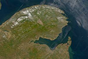
Description: Satellite image of Chaleur Bay below the Gaspé Peninsula.
From: SeaWiFS Level 1A image of the Canadian Maritime provinces and northeastern United States, acquired May 18, 2003.
Source: NASA Goddard Earth Sciences Data and Information Services Center
| This image is from the Sea-viewing Wide Field-of-view Sensor (SeaWiFS) Project and more than 5 years old.
Satellite data captured by the SeaWIFS sensor are released into the public domain 5 years after capture. Data less than five years old can be re-used only for educational or scientific purposes; any commercial use of such images must be coordinated with GeoEye. [1] |
| This work has been released into the public domain by its copyright holder, GeoEye. This applies worldwide. У деяких країнах це не може бути юридично можливо, в такому випадку: GeoEye дає кожному право на використання цієї роботи для будь-яких цілей, без будь-яких умов, якщо такі умови не вимагаються за законом.
|
Історія файлу
Клацніть на дату/час, щоб переглянути, як тоді виглядав файл.
| Дата/час | Мініатюра | Розмір об'єкта | Користувач | Коментар | |
|---|---|---|---|---|---|
| поточний | 09:13, 25 травня 2005 | | 300 × 202 (11 КБ) | Big iron | Description: Satellite image of Chaleur Bay From: SeaWiFS Level 1A image of the Canadian Maritime provinces and northeastern United States, acquired May 18, 2003. Source: NASA Goddard Earth Sciences Data and Information Services Center {{PD-USGov-NASA} |
Використання файлу
Така сторінка використовує цей файл:
Глобальне використання файлу
Цей файл використовують такі інші вікі:
- Використання в ca.wikipedia.org
- Використання в ceb.wikipedia.org
- Використання в de.wikipedia.org
- Використання в en.wikipedia.org
- Використання в eo.wikipedia.org
- Використання в es.wikipedia.org
- Використання в fr.wikipedia.org
- Використання в incubator.wikimedia.org
- Використання в it.wikipedia.org
- Використання в nl.wikipedia.org
- Використання в no.wikipedia.org
- Використання в pl.wikipedia.org
- Використання в pt.wikipedia.org
- Використання в ru.wikipedia.org
- Використання в www.wikidata.org