Файл:Europe rail electrification en.svg
Перейти до навігації
Перейти до пошуку

Розмір цього попереднього перегляду PNG для вихідного SVG-файлу: 688 × 520 пікселів. Інші роздільності: 318 × 240 пікселів | 635 × 480 пікселів | 1016 × 768 пікселів | 1280 × 967 пікселів | 2560 × 1935 пікселів.
Повна роздільність (SVG-файл, номінально 688 × 520 пікселів, розмір файлу: 399 КБ)
| Відомості про цей файл містяться на Вікісховищі — централізованому сховищі вільних файлів мультимедіа для використання у проектах Фонду Вікімедіа. |
| Опис |
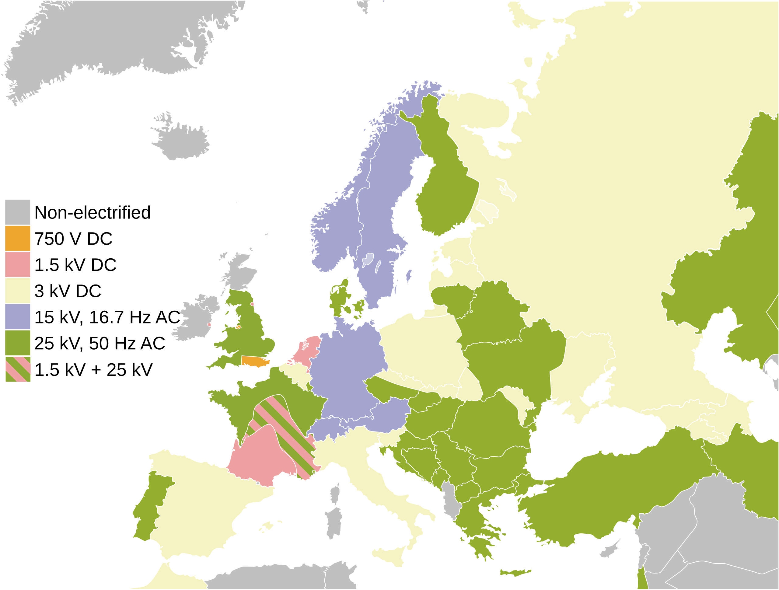
English: Map of the railway electrification systems in Europe
Italiano: Mappa del sistema di elettrificazione ferroviaria in Europa |
| Час створення | |
| Джерело | File:Europe rail electrification.png |
| Автор |
Вектор:
This SVG _?_ includes elements that have been taken or adapted from this _?_: |
| Інші версії | Похідні роботи від цього файлу: Europe rail electrification de.svg |
| SVG розвиток |
| Я, власник авторських прав на цю роботу, передаю роботу в суспільне надбання. Застосовується по всьому світу. У деяких країнах це не може бути юридично можливо, в такому випадку: Я даю кожному право на використання цієї роботи для будь-яких цілей, без будь-яких умов, якщо такі умови не вимагаються за законом. |
Журнал завантажень локального файлу
This image is a derivative work of the following images:
- {{F|Europe_rail_electrification.png|-} licensed with PD-self
- 2009-06-19T01:36:39Z Addams71 450x422 (15616 Bytes) Southeast of Slovakia is not under 25 kV 50 Hz.
- 2009-06-11T19:40:56Z Wangi 450x422 (10607 Bytes) No electrification north of the Central Belt in Scotland
- 2007-10-10T01:27:42Z Jklamo 450x422 (11493 Bytes) small updates, Ireland and Ukraine
- 2007-07-31T20:25:47Z Jklamo 450x422 (11385 Bytes) Map of railway electrification systems in Europe {{legend|#eea631|750 V DC}} {{legend|#a3a5ce|15 kV AC}} {{legend|#f5f0bb|3 kV DC}} {{legend|#eda1a0|1,5 kV DC}} {{legend|#94af2e|25 kV DC}} {{legend|#cdcfd0|non-electrified}}
- File:Blank map europe.svg licensed with PD-USGov-CIA-WF
- 2010-04-18T12:24:45Z Avala 680x520 (528468 Bytes) '
- 2010-04-13T20:46:30Z Patrickneil 680x520 (543089 Bytes) Fut.Perf. added some islands in October, and whether or not the map has Kosovo, it should have the islands
- 2010-04-12T09:04:50Z Zirland 680x520 (528468 Bytes) Reverted to version as of 13:23, 5 December 2009
- 2010-04-09T16:29:37Z Anka Friedrich 680x520 (523284 Bytes) * removed hard coded styles in paths, which prevent colors beeing set by styles for ids or classes * removed style style2412, which colored timezones in southern europe
- 2009-12-05T13:23:39Z Avala 680x520 (528468 Bytes) '
- 2009-10-17T17:24:14Z NuclearVacuum 680x520 (543089 Bytes) some minor editings
- 2009-10-17T14:34:47Z Future Perfect at Sunrise 680x520 (542517 Bytes) added some Greek islands
- 2009-03-25T20:06:19Z Samulili 680x520 (533055 Bytes) Reverted to version as of 15:29, 24 March 2009
- 2009-03-24T23:22:45Z Avala 680x520 (528468 Bytes) this is the original file. upload an alternative for alternative views. simle as that.
- 2009-03-24T15:29:37Z Patrickneil 680x520 (533055 Bytes) The are blank alternatives, that without Kosovo, make this a duplicate file
- 2009-03-20T22:30:51Z Avala 680x520 (528468 Bytes) Reverted to version as of 21:10, 27 May 2007 (original version)
- 2008-10-26T21:20:07Z Cradel 680x520 (533055 Bytes) there is another version of this image
- 2008-10-26T17:25:49Z Avala 680x520 (528468 Bytes) didn't we agree to have alternative files that include disputed territories? this way it is POV, who decides which one deserves to be shown as a country more, Kosovo, Palestine, TRNC, Abkhazia etc.
- 2008-10-25T13:36:13Z Cradel 680x520 (533055 Bytes) what ?
- 2008-10-24T22:42:12Z Avala 680x520 (528468 Bytes) '
- 2008-09-22T13:35:30Z Cradel 680x520 (533055 Bytes) user has been warned
- 2008-09-22T02:11:46Z Tocino 680x520 (528468 Bytes) Reverted to version as of 17:38, 19 September 2008
- 2008-09-20T11:36:04Z Cradel 680x520 (533055 Bytes) Reverted to version as of 18:23, 17 September 2008
- 2008-09-19T17:38:55Z Tocino 680x520 (528468 Bytes) Reverted to version as of 18:12, 17 September 2008
- 2008-09-17T18:23:13Z Cradel 680x520 (533055 Bytes) look at the "other versions" section
- 2008-09-17T18:12:42Z Tocino 680x520 (528468 Bytes) Kosovo is not internationally recognized and this map is used for more than just CIA purposes
- 2008-09-16T16:01:06Z Cradel 680x520 (533055 Bytes) CIA recognises Kosovo, this is their map, do not vandalise it
- 2008-09-16T15:39:16Z Tocino 680x520 (528468 Bytes) Reverted to version as of 00:01, 16 September 2008
- 2008-09-16T10:07:44Z Cradel 680x520 (533055 Bytes) it is a god dammed CIA map
- 2008-09-16T00:01:36Z Tocino 680x520 (528468 Bytes) Reverted to version as of 17:23, 15 September 2008
- 2008-09-15T20:44:48Z Cradel 680x520 (533055 Bytes) Reverted to version as of 19:15, 14 September 2008
- 2008-09-15T17:23:28Z Tocino 680x520 (528468 Bytes) Reverted to version as of 17:03, 14 September 2008
- 2008-09-14T19:15:53Z Cradel 680x520 (533055 Bytes) sigh, please look her : https://www.cia.gov/library/publications/the-world-factbook/geos/kv.html
- 2008-09-14T17:03:29Z Milosevo 680x520 (528468 Bytes) Reverted to version as of 14:45, 13 September 2008 CIA recognizes cosovo? What? And tomorrow ROSKOSMOS recognizes covoso ..
- 2008-09-13T18:08:41Z Cradel 680x520 (533055 Bytes) fix
- 2008-09-13T18:01:06Z Cradel 680x520 (530422 Bytes) this is CIA map, which recognises kosovo
- 2008-09-13T14:45:29Z Avala 680x520 (528468 Bytes) '
- 2008-08-06T20:03:48Z Cradel 680x520 (530422 Bytes) Reverted to version as of 16:17, 4 August 2008
- 2008-08-05T04:35:29Z Rokerismoravee 680x520 (528468 Bytes) Reverted to version as of 14:46, 4 August 2008
- 2008-08-04T16:17:13Z Cradel 680x520 (530422 Bytes) Reverted to version as of 12:09, 3 August 2008
- 2008-08-04T14:46:55Z Rokerismoravee 680x520 (528468 Bytes) Reverted to version as of 13:14, 2 August 2008
- 2008-08-03T12:09:59Z Cradel 680x520 (530422 Bytes) again : what are you talking about
- 2008-08-02T13:14:48Z Milosevo 680x520 (528468 Bytes) Territory of Kosovo isn't correct
- 2008-08-02T12:48:39Z Cradel 680x520 (530422 Bytes) this map was taken from the CIA world Factbook, which recognises Kosovo so please
- 2008-08-01T21:28:39Z Rokerismoravee 680x520 (528468 Bytes) Reverted to version as of 12:54, 1 August 2008
- 2008-08-01T19:07:24Z Cradel 680x520 (530422 Bytes) Reverted to version as of 20:44, 9 June 2008
- 2008-08-01T12:54:32Z Rokerismoravee 680x520 (528468 Bytes) Reverted to version as of 17:34, 9 June 2008
- 2008-06-09T20:44:17Z Cradel 680x520 (530422 Bytes) Reverted to version as of 17:01, 9 June 2008
- 2008-06-09T17:34:51Z Milosevo 680x520 (528468 Bytes) Reverted to version as of 14:14, 9 June 2008
- 2008-06-09T17:01:41Z Cradel 680x520 (530422 Bytes) Reverted to version as of 20:14, 8 June 2008
- 2008-06-09T14:14:04Z Milosevo 680x520 (528468 Bytes) revert, vandalism. No UN-Member
- 2008-06-08T20:14:58Z Cradel 680x520 (530422 Bytes) Reverted vandalism
- 2008-06-08T15:21:43Z Milosevo 680x520 (528468 Bytes) Reverted to version as of 21:10, 27 May 2007
- 2008-05-30T12:01:01Z Cradel 680x520 (530422 Bytes) + Kosovo
- 2007-05-27T21:10:55Z Ssolbergj 680x520 (528468 Bytes) '
Uploaded with derivativeFX
Історія файлу
Клацніть на дату/час, щоб переглянути, як тоді виглядав файл.
| Дата/час | Мініатюра | Розмір об'єкта | Користувач | Коментар | |
|---|---|---|---|---|---|
| поточний | 05:50, 6 вересня 2022 | | 688 × 520 (399 КБ) | Рагин1987 | Correction |
| 05:47, 6 вересня 2022 |  | 680 × 520 (557 КБ) | Рагин1987 | Added countries | |
| 11:52, 30 травня 2022 |  | 688 × 520 (399 КБ) | Guerillero | Reverted to version as of 18:07, 21 June 2021 (UTC) new versions are blank | |
| 11:00, 29 травня 2022 |  | 3200 × 2419 (17 КБ) | Kieran1398 | Reverted to version as of 10:30, 29 May 2022 (UTC) | |
| 11:00, 29 травня 2022 |  | 860 × 650 (11 КБ) | Kieran1398 | added the Isle of Wight and put holy island on the map | |
| 10:55, 29 травня 2022 |  | 688 × 520 (399 КБ) | Kieran1398 | Reverted to version as of 18:07, 21 June 2021 (UTC) i forgot to scale down the svg | |
| 10:30, 29 травня 2022 |  | 3200 × 2419 (17 КБ) | Kieran1398 | added the Isle of Wight and put holy island on the map | |
| 18:07, 21 червня 2021 |  | 688 × 520 (399 КБ) | Voello | Changed the Hebrides, Orkney, Shetland and Faroe islands to non-electrified, as they do not have any electrified railways | |
| 17:58, 20 червня 2021 |  | 688 × 520 (397 КБ) | Voello | Corrected colouring of DART in Ireland | |
| 14:51, 15 січня 2020 |  | 688 × 520 (397 КБ) | Razorblack | Added white background below transparency. Colored in Iran, Kazakhstan, Uzbekistan, Israel with 25kV, 50Hz. |
Використання файлу
Така сторінка використовує цей файл:
Глобальне використання файлу
Цей файл використовують такі інші вікі:
- Використання в ar.wikipedia.org
- Використання в bg.wikipedia.org
- Використання в bn.wikipedia.org
- Використання в cs.wikipedia.org
- Використання в en.wikipedia.org
- Використання в es.wikipedia.org
- Використання в fr.wikipedia.org
- Використання в hu.wikipedia.org
- Використання в id.wikipedia.org
- Використання в ko.wikipedia.org
- Використання в lb.wikipedia.org
- Використання в mk.wikipedia.org
- Використання в th.wikipedia.org
- Використання в uz.wikipedia.org
- Використання в vi.wikipedia.org