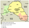
Файл:Hungarian autonomous province02.png
Зовнішній вигляд

Розмір при попередньому перегляді: 619 × 599 пікселів. Інші роздільності: 248 × 240 пікселів | 496 × 480 пікселів | 751 × 727 пікселів.
Повна роздільність (751 × 727 пікселів, розмір файлу: 60 КБ, MIME-тип: image/png)
Історія файлу
Клацніть на дату/час, щоб переглянути, як тоді виглядав файл.
| Дата/час | Мініатюра | Розмір об'єкта | Користувач | Коментар | |
|---|---|---|---|---|---|
| поточний | 18:59, 26 березня 2013 |  | 751 × 727 (60 КБ) | WikiEditor2004 | Reverted to version as of 13:05, 24 October 2011 I do not agree with your changes, please upload your file under different name |
| 09:09, 26 березня 2013 |  | 619 × 599 (103 КБ) | Rgvis | Improved version with administrative borders changes shown during the existance of the Soviet-inspired administrative and territorial organisation in Communist Romania (1950-1968). | |
| 13:05, 24 жовтня 2011 |  | 751 × 727 (60 КБ) | WikiEditor2004 | improved version | |
| 18:56, 28 грудня 2006 |  | 716 × 620 (11 КБ) | Electionworld | {{ew|en|PANONIAN}} map of the Hungarian Autonomous Province (self made) {{PD-self}} Category:Maps of the history of Romania |
Використання файлу
Така сторінка використовує цей файл:
Глобальне використання файлу
Цей файл використовують такі інші вікі:
- Використання в ar.wikipedia.org
- Використання в be.wikipedia.org
- Використання в bg.wikipedia.org
- Використання в ca.wikipedia.org
- Використання в en.wikipedia.org
- Використання в es.wikipedia.org
- Використання в fr.wikipedia.org
- Використання в hu.wikipedia.org
- Використання в it.wikipedia.org
- Використання в mk.wikipedia.org
- Використання в nl.wikipedia.org
- Використання в pl.wikipedia.org
- Використання в pt.wikipedia.org
- Використання в ro.wikipedia.org
- Використання в ru.wikipedia.org
- Використання в sl.wikipedia.org
- Використання в sr.wikipedia.org
- Використання в www.wikidata.org


