Файл:London north-south circulars.svg
Перейти до навігації
Перейти до пошуку

Розмір цього попереднього перегляду PNG для вихідного SVG-файлу: 715 × 600 пікселів. Інші роздільності: 286 × 240 пікселів | 572 × 480 пікселів | 916 × 768 пікселів | 1221 × 1024 пікселів | 2442 × 2048 пікселів | 4542 × 3809 пікселів.
Повна роздільність (SVG-файл, номінально 4542 × 3809 пікселів, розмір файлу: 46 КБ)
| Відомості про цей файл містяться на Вікісховищі — централізованому сховищі вільних файлів мультимедіа для використання у проектах Фонду Вікімедіа. |

Опис файлу
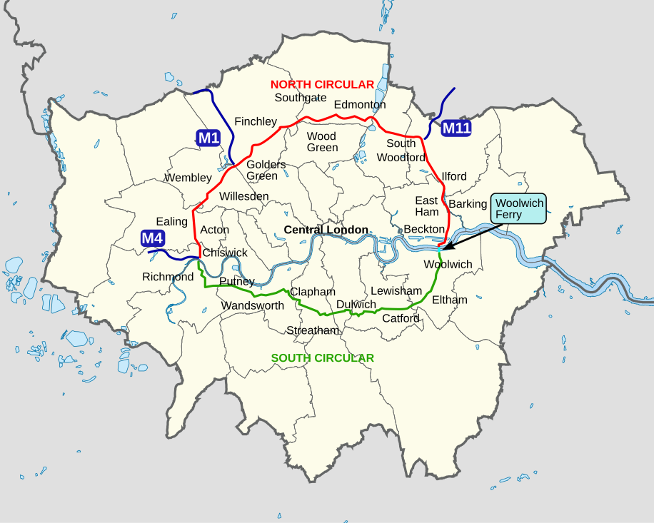
| Опис | An outline map of the North Circular and South Circular roads, including the Woolwich Ferry linking the two. |
| Час створення | |
| Джерело | Власна робота |
| Автор | Cnbrb |
Ліцензування
| Я, власник авторських прав на цю роботу, передаю роботу в суспільне надбання. Застосовується по всьому світу. У деяких країнах це не може бути юридично можливо, в такому випадку: Я даю кожному право на використання цієї роботи для будь-яких цілей, без будь-яких умов, якщо такі умови не вимагаються за законом. |
Історія файлу
Клацніть на дату/час, щоб переглянути, як тоді виглядав файл.
| Дата/час | Мініатюра | Розмір об'єкта | Користувач | Коментар | |
|---|---|---|---|---|---|
| поточний | 11:45, 29 жовтня 2022 | | 4542 × 3809 (46 КБ) | Hanif Al Husaini | Lighten background to make higher contrast with the green text and line for the South Circular |
| 01:17, 13 травня 2019 |  | 4542 × 3809 (46 КБ) | MetrolandNW | Further pinpoint fixes for accuracy, added other notable places | |
| 22:00, 11 травня 2019 |  | 4542 × 3809 (43 КБ) | MetrolandNW | Fixes for place names (now mentions major places near/on the roads), corrected words' locations for accuracy ('Friern Barnet' especially was extremely unaccurate), coloured 'NORTH CIRCULAR' and 'SOUTH CIRCULAR' (to their respective lines' colours) | |
| 22:15, 24 березня 2008 |  | 4542 × 3809 (39 КБ) | Cnbrb | {{Information |Description=An outline map of the North Circular and South Circular roads, including the Woolwich Ferry linking the two. |Source=self-made |Date=2008-03-24 |Author= Cnbrb |Permission= |other_versions= }} | |
| 22:01, 24 березня 2008 |  | 4542 × 3809 (40 КБ) | Cnbrb | {{Information |Description=An outline map of the North Circular and South Circular roads, including the Woolwich Ferry linking the two. |Source=self-made |Date=2008-03-24 |Author= Cnbrb |Permission= |other_versions= }} |
Використання файлу
Такі сторінки використовують цей файл:
Глобальне використання файлу
Цей файл використовують такі інші вікі:
- Використання в en.wikipedia.org
- Використання в ga.wikipedia.org
- Використання в no.wikipedia.org
- Використання в simple.wikipedia.org
- Використання в www.wikidata.org