
Файл:Nansen Fram Map rus.png
Розмір при попередньому перегляді: 800 × 479 пікселів. Інші роздільності: 320 × 192 пікселів | 640 × 383 пікселів | 1003 × 601 пікселів.
Повна роздільність (1003 × 601 пікселів, розмір файлу: 84 КБ, MIME-тип: image/png)
| Відомості про цей файл містяться на Вікісховищі — централізованому сховищі вільних файлів мультимедіа для використання в проектах Фонду Вікімедіа. |
| Опис |
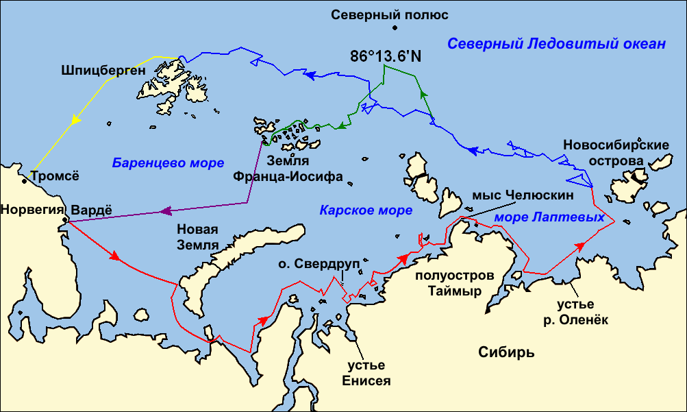
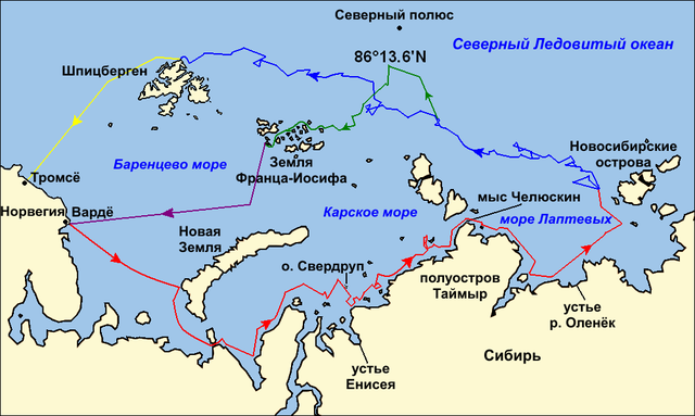
Map of the Arctic Ocean showing the routes taken during the 1893–96 Nansen's Fram expedition: Frams's route eastward from Vardø to the Siberian coast, turning north at the New Siberian Islands to enter the pack ice. July – September 1893 Fram's drift in the ice from the New Siberian Islands, north and west to Spitsbergen, September 1893 – August 1896 Nansen and Johansen's march to Farthest North, 80°20'N, and their subsequent retreat to Cape Flora in Franz Josef Land. February 1895 – June 1896 Nansen and Johansen's return to Vardø from Cape Flora, August 1896 Fram's voyage from Spitsbergen to Tromsø, August 1896 |
| Час створення | (UTC) |
| Джерело | |
| Автор |
|
| Інші версії |
|

| Це відредаговане зображення, тобто одержане цифровою обробкою з оригіналу. Зміни: текст на русском языке (russian text). Початкове зображення знаходиться тут: Nansen Fram Map.png. Відредагував Ivengo(RUS).
|
Я, власник авторських прав на цей твір, добровільно публікую його на умовах таких ліцензій:
Цей файл доступний на умовах ліцензій Creative Commons Attribution-Share Alike 3.0 Unported, 2.5 Generic, 2.0 Generic та 1.0 Generic.
- Ви можете вільно:
- ділитися – копіювати, поширювати і передавати твір
- модифікувати – переробляти твір
- При дотриманні таких умов:
- зазначення авторства – Ви повинні вказати авторство, надати посилання на ліцензію і вказати, чи якісь зміни було внесено до оригінального твору. Ви можете зробити це в будь-який розсудливий спосіб, але так, щоб він жодним чином не натякав на те, наче ліцензіар підтримує Вас чи Ваш спосіб використання твору.
- поширення на тих же умовах – Якщо ви змінюєте, перетворюєте або створюєте іншу похідну роботу на основі цього твору, ви можете поширювати отриманий у результаті твір тільки на умовах такої ж або сумісної ліцензії.

|
Дозволяється копіювати, розповсюджувати та/або модифікувати цей документ на умовах ліцензії GNU FDL версії 1.2 або більш пізньої, виданої Фондом вільного програмного забезпечення, без незмінних розділів, без текстів, які розміщені на першій та останній обкладинці. Копія ліцензії знаходиться у розділі GNU Free Documentation License. |
Ви можете обрати ліцензію на ваш розсуд.
Журнал завантажень локального файлу
This image is a derivative work of the following images:
- File:Nansen_Fram_Map.png licensed with Cc-by-sa-3.0,2.5,2.0,1.0, GFDL
- 2009-10-21T15:50:57Z Ruhrfisch 1003x601 (79935 Bytes) Make arrowheads less triangular (indentations at rear)
- 2009-10-21T15:23:20Z Ruhrfisch 1003x601 (79868 Bytes) Add arrowheads per FAC
- 2009-10-20T18:50:18Z Ruhrfisch 1003x601 (79825 Bytes) Make magenta line purple
- 2009-10-11T13:36:40Z Ruhrfisch 1003x601 (79831 Bytes) Yellow line for orange, some labels smaller, Farthest North replaced with actual figure, all other info the same
- 2009-10-11T03:08:59Z Ruhrfisch 1003x601 (81994 Bytes) Darker green for that line, all other information is the same
- 2009-10-11T02:46:31Z Ruhrfisch 1003x601 (81987 Bytes) Added last two lines for ice voyages, added last labels, all other information the same.
- 2009-10-09T19:30:04Z Ruhrfisch 1003x601 (75047 Bytes) Add labels, two more voyage lines, all other information is the same
- 2009-10-09T16:12:36Z Ruhrfisch 1003x601 (57897 Bytes) == Summary == {{Information |Description = Map of the Arctic Ocean showing the path of [[w:Nansen's Fram expedition|Nansen's Fram expedition]] 1893 to 1896 |Source = Base map of European mainland is from [[:File:Ma
Uploaded with derivativeFX
Історія файлу
Клацніть на дату/час, щоб переглянути, як тоді виглядав файл.
| Дата/час | Мініатюра | Розмір об'єкта | Користувач | Коментар | |
|---|---|---|---|---|---|
| поточний | 23:06, 8 січня 2011 | | 1003 × 601 (84 КБ) | Ivengo(RUS) | {{Information |Description=Map of the Arctic Ocean showing the routes taken during the 1893–96 Nansen's Fram expedition: {{legend|red|Frams's route eastward from Vardø to the Siberian coast, turning north at the New Sibe |
Використання файлу
Така сторінка використовує цей файл:
Глобальне використання файлу
Цей файл використовують такі інші вікі:
- Використання в ba.wikipedia.org
- Використання в be.wikipedia.org
- Використання в bg.wikipedia.org
- Використання в hy.wikipedia.org
- Використання в kk.wikipedia.org
- Використання в ru.wikipedia.org