Файл:Overtoun Bridge - geograph.org.uk - 1024544.jpg
Overtoun_Bridge_-_geograph.org.uk_-_1024544.jpg (640 × 480 пікселів, розмір файлу: 110 КБ, MIME-тип: image/jpeg)
| Відомості про цей файл містяться на Вікісховищі — централізованому сховищі вільних файлів мультимедіа для використання у проектах Фонду Вікімедіа. |
Опис файлу
| Опис |
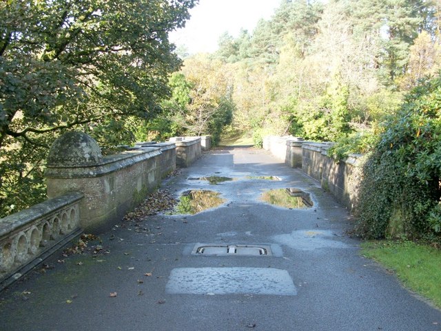
English: Overtoun Bridge. This thick-sided stone bridge, located next to 59380, has parapets on both sides; the river gorge that it crosses has sides that fall away steeply, and the river is therefore located a surprising distance below the bridge.
Overtoun House was built in 1859-63 for the Rutherglen chemical manufacturer James White (1735631), whose son became the first Lord Overtoun, but the bridge dates from 1895, and was built by H.E.Milner ["North Clyde Estuary - An Illustrated Architectural Guide", Frank Arneil Walker with Fiona Sinclair]. Although his son, John Campbell White (the aforementioned Lord Overtoun), was well known for his charitable works, he was famously lambasted in 1899 by Keir Hardie, who exposed the appalling working conditions faced by those employed in his chemical factory. [The location has featured in news reports more than once. In 1994, a mentally-disturbed man threw his two-week-old son to his death from the bridge. In October 2006, the fact that a surprising number of dogs have leapt to their death from the bridge was the subject of a television programme. This phenomenon has been reported under the sensational and misleading title of "dog suicides". Suggested explanations have ranged from the supernatural to peculiar sonic effects in the structure of the bridge; however, among the more plausible explanations is the idea that something (perhaps the scent of mink) is tempting dogs, from whose viewpoint the long drop is not apparent, to leap the bridge wall.] |
| Час створення | |
| Джерело | From geograph.org.uk |
| Автор | Lairich Rig |
| Зазначення авторства (вимагається ліцензією) | Lairich Rig / Overtoun Bridge / |
| Місцеположення камери | | Перегляньте це та інші зображення поблизу на: OpenStreetMap |
|---|
_heading:292.00&language=uk)
| Місцеположення об’єкта | | Перегляньте це та інші зображення поблизу на: OpenStreetMap |
|---|
_heading:292.00&language=uk)
Ліцензування

|
Це зображення походить із колекції проекту «Geograph Britain and Ireland».
Контакти автора знімка є на сторінці знімка в проекті Geograph. Авторські права на зображення належать Lairich Rig. Зображення поширюється на умовах ліцензії Creative Commons Attribution-ShareAlike 2.0.
|
- Ви можете вільно:
- ділитися – копіювати, поширювати і передавати твір
- модифікувати – переробляти твір
- При дотриманні таких умов:
- зазначення авторства – Ви повинні вказати авторство, надати посилання на ліцензію і вказати, чи якісь зміни було внесено до оригінального твору. Ви можете зробити це в будь-який розсудливий спосіб, але так, щоб він жодним чином не натякав на те, наче ліцензіар підтримує Вас чи Ваш спосіб використання твору.
- поширення на тих же умовах – Якщо ви змінюєте, перетворюєте або створюєте іншу похідну роботу на основі цього твору, ви можете поширювати отриманий у результаті твір тільки на умовах такої ж або сумісної ліцензії.
Історія файлу
Клацніть на дату/час, щоб переглянути, як тоді виглядав файл.
| Дата/час | Мініатюра | Розмір об'єкта | Користувач | Коментар | |
|---|---|---|---|---|---|
| поточний | 14:58, 23 лютого 2011 | | 640 × 480 (110 КБ) | GeographBot | == {{int:filedesc}} == {{Information |description={{en|1=Overtoun Bridge This thick-sided stone bridge, located next to 59380, has parapets on both sides; the river gorge that it crosses has sides that fall away steeply, and the river is therefore loc |
Використання файлу
Така сторінка використовує цей файл:
Глобальне використання файлу
Цей файл використовують такі інші вікі:
- Використання в de.wikipedia.org
- Використання в fa.wikipedia.org
- Використання в fr.wikipedia.org
- Використання в hy.wikipedia.org
- Використання в it.wikipedia.org
- Використання в ru.wikipedia.org
- Використання в www.wikidata.org
- Використання в zh.wikipedia.org