Файл:SAR Kilauea.jpg

Повна роздільність (1000 × 1000 пікселів, розмір файлу: 333 КБ, MIME-тип: image/jpeg)
| Відомості про цей файл містяться на Вікісховищі — централізованому сховищі вільних файлів мультимедіа для використання у проектах Фонду Вікімедіа. |
| Опис | PIA01763: Space Radar Image of Kilauea, Hawaii - interferometry 1 |
| Час створення | |
| Джерело | http://photojournal.jpl.nasa.gov/catalog/PIA01763 |
| Автор | JPL |
| Ліцензія (Повторне використання цього файлу) |
Courtesy NASA/JPL-Caltech, http://www.jpl.nasa.gov/images/policy/ |
| Цей файл перебуває у суспільному надбанні, оскільки він був створений NASA (Національним управлінням з аеронавтики і дослідження космічного простору). Згідно з політикою NASA стосовно авторського права, «матеріали NASA не захищаються авторським правом, якщо не вказано протилежне». (Див. Template:PD-USGov, сторінку політики NASA стосовно авторського права, або політику використання зображень JPL.) | ||
 |
Попередження:
|
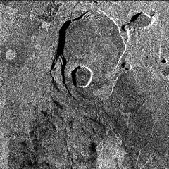
Original Caption Released with Image: Data acquired on April 13, 1994 and on October 4, 1994 from the X-band Synthetic Aperture Radar on board the space shuttle Endeavour were used to generate interferometric fringes, which were overlaid on the X-SAR image of Kilauea. The volcano is centered in this image at 19.58 degrees north latitude and 155.55 degrees west longitude. The image covers about 9 kilometers by 13 kilometers (5.6 miles by 8 miles). The X-band fringes correspond clearly to the expected topographic image. The yellow line indicates the area below which was used for the three-dimensional image using altitude lines. The yellow rectangular frame fences the area for the final topographic image.
Spaceborne Imaging Radar-C and X-band Synthetic Aperture Radar (SIR-C/X-SAR) is part of NASA's Mission to Planet Earth. The radars illuminate Earth with microwaves, allowing detailed observations at any time, regardless of weather or sunlight conditions. SIR-C/X-SAR uses three microwave wavelengths: L-band (24 cm), C-band (6 cm) and X-band (3 cm). The multi-frequency data will be used by the international scientific community to better understand the global environment and how it is changing. The SIR-C/X-SAR data, complemented by aircraft and ground studies, will give scientists clearer insights into those environmental changes which are caused by nature and those changes which are induced by human activity.
SIR-C was developed by NASA's Jet Propulsion Laboratory. X-SAR was developed by the Dornier and Alenia Spazio companies for the German space agency, Deutsche Agentur fuer Raumfahrtangelegenheiten (DARA), and the Italian space agency, Agenzia Spaziale Italiana (ASI), with the Deutsche Forschungsanstalt fuer Luft und Raumfahrt e.V.(DLR), the major partner in science, operations and data processing of X-SAR. The Instituto Ricerca Elettromagnetismo Componenti Elettronici (IRECE) at the University of Naples was a partner in interferometry analysis.
| Анотації | Це зображення має анотації: Переглянути анотації на Вікісховищі |
Історія файлу
Клацніть на дату/час, щоб переглянути, як тоді виглядав файл.
| Дата/час | Мініатюра | Розмір об'єкта | Користувач | Коментар | |
|---|---|---|---|---|---|
| поточний | 10:50, 30 березня 2007 | | 1000 × 1000 (333 КБ) | Eve Hall~commonswiki | {{Information |Description=PIA01763: Space Radar Image of Kilauea, Hawaii - interferometry 1 |Source=http://photojournal.jpl.nasa.gov/catalog/PIA01763 |Date=1999-05-01 |Author=JPL |Permission=Courtesy NASA/JPL-Caltech, http://www.jpl.nasa.gov/images/polic |
Використання файлу
Така сторінка використовує цей файл:
Глобальне використання файлу
Цей файл використовують такі інші вікі:
- Використання в en.wikipedia.org
- Використання в es.wikipedia.org
- Використання в et.wikipedia.org
- Використання в zh.wikipedia.org